 |
|
Archway - Tower Bank |
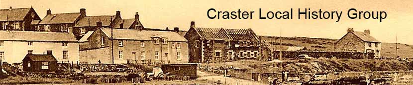
Craster Village
|
|

Mary Craster, in 'We Can Mind the Time' wrote...
"...until the late 18th century, Craster village was still at the top of the hill, immediately north and east of Craster Tower. A map of 1723 shows an E-W road with 12 houses in 2 rows on each side of it still to be seen in the pasture, running straight down the bank next to the Tower. The present road did not exist and there was nothing by the sea apart from the little cove where the fishing boats were beached."
"George Craster (died 1772), married Olive Sharpe, daughter of a neighbour at Gray's Inn and in 1760 they set off on an extended Grand Tour of Europe; South France, Rome, Florence, Venice and back to Paris. On their return they decided to enlarge and modernise Craster Tower, building a Georgian wing with pedimented front door on the South courtyard. A kitchen-garden was also constructed with its North wall backing onto a row of cottages at the southern edge of Dunstan (thus warming the garden wall). These form the present Cottage Inn. The Summer House on the SE point of Craster haven was also built as a picnic house for the Craster family."
Of Shafto Craster (born 1755, inherited the estate in 1784, died 1837) she wrote:
"He built the school in Dunstan and laid out tree plantations round the Tower gardens. He it was that completed the removal of the village to the sea. It was known as Craster Seahouses as late as 1828. In 1822 he built Craster Square on the hill behind where Robson's Yard now is, as housing for the fishermen. This was pulled down in 1962. A water reservoir was also built and coastguards' cottages (the castellated) building on the hill above Bark Pots tea rooms.
The road past the Tower on the North side of the house was moved further away, making the Avenue, from the Pillars at the new cross-roads and leading through the sham Gothic archway and down the bank."
Included in Mary's sources was Sir Edmund Craster's 'The History of the Craster Family' in the Society of Antiquaries of Newcastle upon Tyne, Overprint from Archaeolgia Aeliana 4th Series Volume 30, March 1953, where we find, speaking of Shafto Craster:
"He certainly made many improvements at Craster, notably that of removing the village from its old site on the north of the Hall, and building in place of it, as houses for his fishermen, the still-standing Craster Square down by the Haven. The new village went at first by the name of Craster Sea-houses. He also laid out plantations round the Hall, and probably at the same time diverted the road down to the sea. This had formerly run close to the back of the Tower. He moved it further away, so that it took its present line from Craster Pillars to the sham Gothic archway at the seaward end of the avenue."
"It is unfortunate that we do not know more than we do of Shafto Craster, last representative of his family in the male line and squire for well over fifty years. His personal papers were carried off by his daughter and have vanished. It is clear, however, that he gave close attention to the life of the village where it seems that he started the herring-curing industry. He founded in 1825 a school at Dunstan for the education of twenty-five poor children from Dunstan and Craster, charging the farm of Spittleford with an annuity of £30 for the schoolmaster. Besides subscribing liberally to charitable institutions, he gave private assistance to families in reduced circumstances, paid for medical attention to be given to the poor, and appointed agents for distribution of money in charity. The best testimonial to his memory is that given by his lawyer, Mr. Lambert, who wrote of' him, 'A more just, upright and benevolent person, it may be truly said, clever had existence.'
On May 7th, 1837, he died, but his daughter was in no hurry to have him buried. When the funeral did take place three weeks later, the hearse, the mourning coaches and the family carriages were followed by thirteen other carriages, and they by a retinue of tenantry and other attendants. The procession extended for nearly a mile, and so the long line moved slowly up the hill from Spittleford towards Embleton, where the entire population had turned out, and the coffin was finally deposited in the family vault."
"Reproduced from the 1897 Ordnance Survey map with the kind permission of Ordnance Survey" |

The History of Northumberland, Ed. Bateson, 1892, has the following...
"...the village of Craster, standing upon the shore where an indentation in the rock forms a natural haven for the cobles of the fishermen. Two limestone islets, the Little Carr to the north and the Muckle Carr to the south, act as a natural breakwater, and render the haven a safe anchorage except in very boisterous weather. A small stream which finds its way through a gap in the heugh divides the village into two parts, known as the 'north side' and 'south side.' The inhabitants, no longer so numerous as formerly, maintain themselves chiefly by fishing, and have many characteristics which distinguish them from the agricultural people of the neighbouring villages. A stranger will receive a pleasing impression from the fisherfolk. He will observe their fine physique, their rugged but handsome features, and the peculiar softness of their speech. These traits, in some measure due to the simple and healthy occupation of the people, have been developed by their manner of life. The similarity of their names (and it would be hard to find a Craster man who is not an Archbold or a Simpson) shows that the inhabitants of Craster, as of other fishing villages along the coast of Northumberland, are a colony apart."
In the same volume the following Census Returns are given:
1801 1851 |
1811 1861 |
1821 1871 |
1831 1881 |
1841 1891 |
It notes: "The diminution is due to the decrease of the agricultural part of the population. The size of the township is 648 acres." This remark presumably refers to the decline between 1881 and 1891, a decline of 28%.
The National Gazetteer of Great Britain and Ireland (1868) has the following entry:
"CRASTER, a township in the parish of Embleton, Bamburgh ward, in the county of Northumberland, 5½ miles N.E. of Alnwick, its post town. The village, situated near the coast of the North Sea, is called Craster Sea Houses. Craster Tower, the seat of Thomas Wood Craster, Esq., is a fine structure of basalt, and commands a view of the German Ocean through the chasms of a bold chain of rocks running between it and the sea."l
White's Directory of 1841 says, "Craster Township, 6 miles NE of Alnwick contains a small village called Craster Sea Houses..." Kelly's Directory of 1879 refers to, "Craster, situated on the German Ocean." Bulmer's Directory of 1887 says, "...the village of Craster, a short distance from the sea, is occupied by persons employed chiefly in fishing and the fish curing trade." Kelly's Directory of 1897 says, "Herring and other fisheries are carried on here to a considerable extent, there are large premises erected for curing herring in the occupation of Messrs W. Archbold & Sons, Mr Robert Grey and Messrs J. & C. Archbold. Here is a coastguard station with rocket apparatus, the property of the Board of Trade, the staff consists of one chief officer and four boatmen."
A village diary was found in William Robert Archbold's collection in the form of notes on exercise paper that appeared to have been copied from an older source. Unfortunately they are without provenance. They may be read by following this link.
It appears that this extract is from the same original document as the larger extract from Eva Archbold's collection. This may be read as a Word document by following this link:
 |
Home Programme Membership Archive War Memorials History Walk Miscellanea Links Contact Us